Carlisle, Massachusetts · Groundwater first

Protect our water.Plan our center.

Carlisle's drinking water comes from the ground. Its wastewater goes back there too. A focused feasibility study can test whether shared public infrastructure would better protect groundwater, sustain public buildings, and keep the historic center useful—without sewering the town.

The local water cycleConcept diagram · not to scale
Home
Town center
Well intake
Septic system
soil + treatment
shared groundwater environment
drawWhat goes into the ground matters to what comes out.return
Protect groundwaterUse existing assetsStudy before decidingKeep the scope local

One connected system

Our water comes from the ground.Our wastewater goes there too.

A conventional septic system treats wastewater through a tank, soil, and natural processes before effluent reaches the groundwater environment. That is treated effluent—not raw sewage—but soil does not remove every nutrient or contaminant.

This is not an argument against septic systems. It is a reason to look carefully at density, cumulative loading, aging systems, and alternatives in the one part of town where public uses sit close together.

Carlisle's own record

The case starts with local data.

These numbers come from Carlisle's water and wastewater regulations. They are context for study—not claims that groundwater is currently contaminated or that every septic system is failing.

01100%

Groundwater dependent

Carlisle has no municipal water supply. Homes, businesses, and public buildings rely on on-site wells.

0267%

Title 5 pass rate

Carlisle reports a 67% average pass rate for inspections from 2019–2023—roughly 1 in 3 inspections did not pass.

0350%

Larger local footprint

Carlisle requires 165 rather than 110 gallons per day per bedroom for the first three bedrooms.

049 in

Annual recharge

Carlisle’s representative recharge rate is half the 18-inch default used in MassDEP nitrogen-loading guidance.

05440

GPD per acre

The local nitrogen-loading limit applies to qualifying new construction and increases in design capacity.

0620–30

Years of design life

That is Carlisle’s cited design-life range for a properly sited, constructed, and maintained soil absorption system.

“Roughly 1 in 3 inspections did not pass” describes inspections during the cited five-year period. It does not mean one-third of all Carlisle systems are currently failing.

A plan with history

Carlisle has been here before.

In 2010, the Board of Health pursued a town-center wastewater extension beginning with the Library and Village Court. It was not built. The underlying constraints did not disappear—so today's question is whether a limited connection makes sense under current engineering, costs, and public priorities.

2010First proposal

Board of Health advances a town-center extension.

The initial concept connected Gleason Public Library and Village Court to the school treatment facility. It included a state low-interest-loan application and anticipated later public discussion and approvals.

2026Current study

New engineering asks what is feasible now.

The current scope begins with the Library and public restrooms at Ferns, then tests selected civic buildings. Capacity, route, environmental performance, cost, governance, and funding all remain to be verified.

The center, made visible

Maps turn a general idea into a testable question.

The materials show a compact cluster of civic buildings, the Ferns parcel, drinking-water protection context, and a possible corridor to the school treatment facility. They do not establish a final route or engineering design.

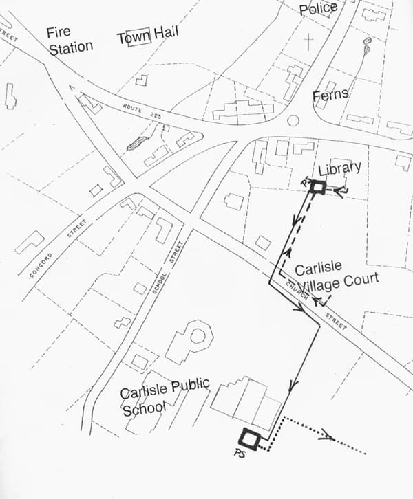
Working Carlisle town center wastewater connection diagram showing Ferns, the library, public safety buildings, Town Hall, Village Court, and the school treatment facility
Map 01

A working connection concept

Committee materials sketch a potential center corridor linking selected public buildings and Ferns to the Carlisle School treatment facility. Alignment, pumps, easements, and cost all require engineering.

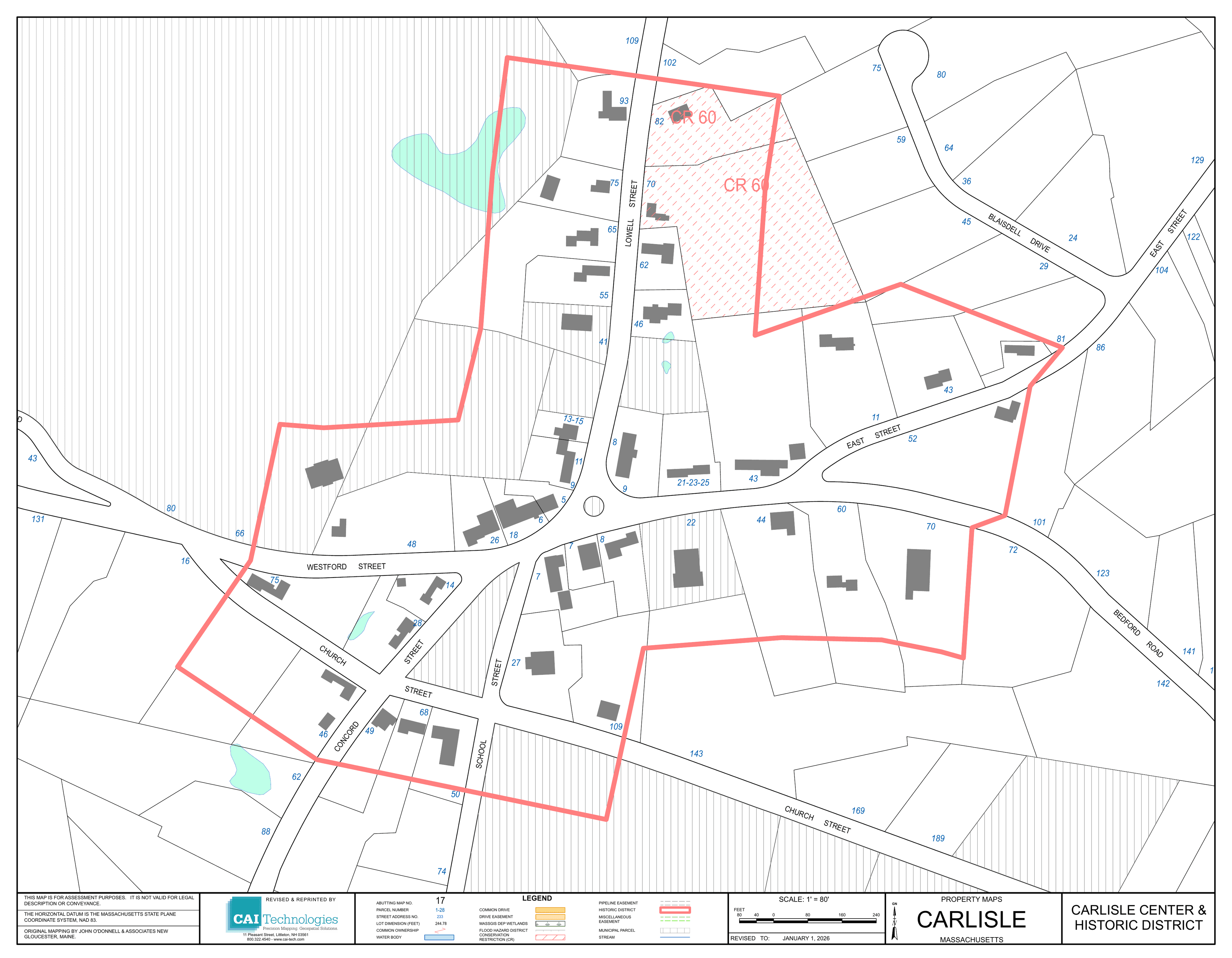
Carlisle Center and Historic District parcel map
Map 02

Center parcels + civic cluster

A Town GIS parcel export locates the historic center and nearby public properties along Lowell, Bedford, School, Church, East, and Westford Roads.

Open full parcel map ↗
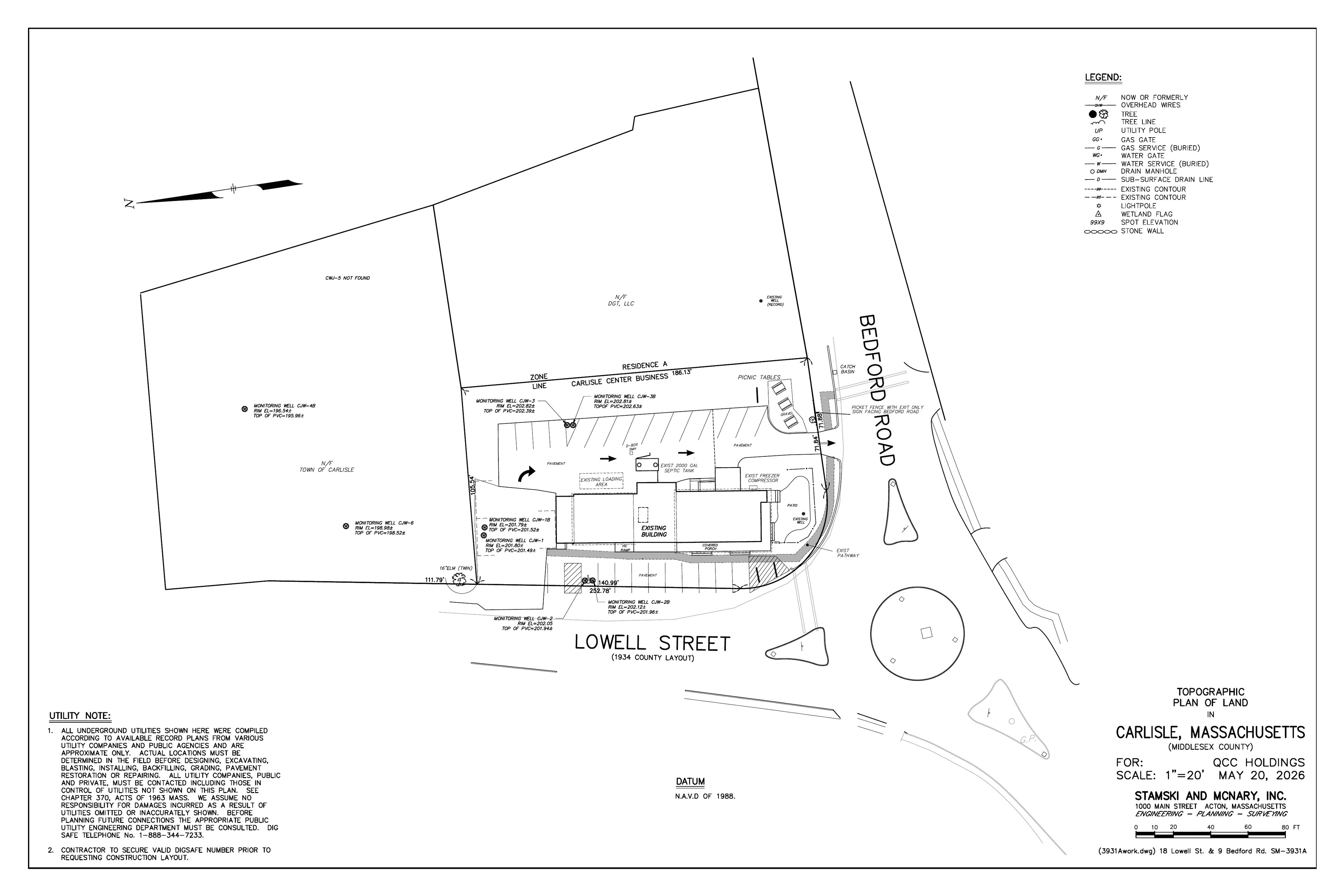
May 2026 engineering site plan for the Ferns property at 18 Lowell Street and 9 Bedford Road
Plan 03

The Ferns site is constrained

The May 2026 plan documents the parcel, buildings, wells, monitoring wells, existing septic components, grades, and surrounding property context.

Open full plot plan ↗
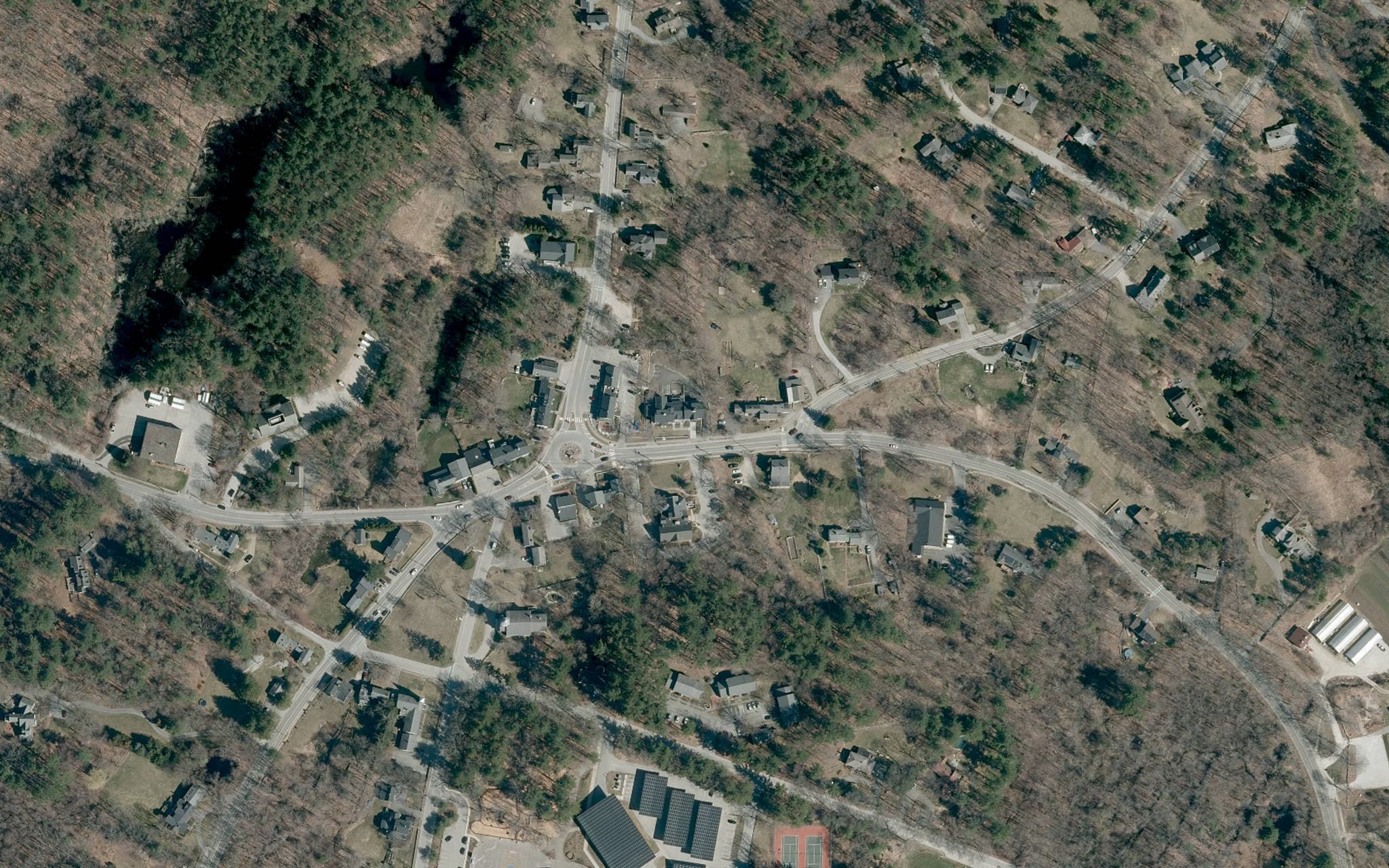
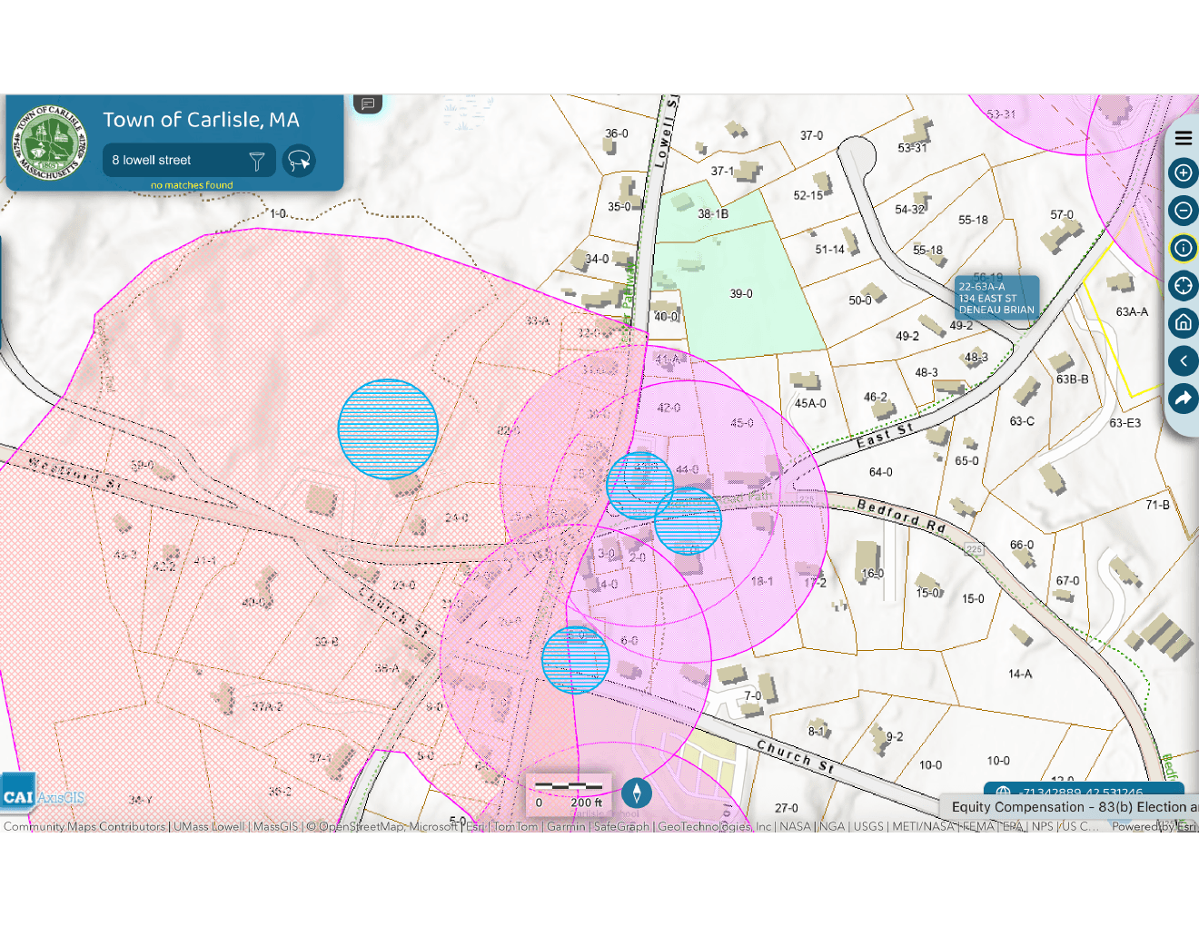
Carlisle GIS view of the Ferns parcel and nearby wellhead protection areas

Zone I

Drinking-water protection starts here.

MassDEP defines Zone I as the primary protective area around a public water-system well. The Ferns property materials place the site in the protection area associated with a nearby public-supply well—one reason wastewater options deserve careful review.

Important boundary

This map is specific to the Ferns property and nearby well context. It does not show that the entire town center is Zone I. MassGIS layers are advisory and require field verification.

Open the full wellhead map ↗

A bounded public-infrastructure study

Start small. Measure everything. Expand only if it works.

Weston & Sampson's July 2026 feasibility-study proposal begins with the Library and public restrooms at Ferns, then tests whether a broader group of center buildings could be served. The study is not design, permitting, construction, or approval.

01

Library + public restrooms

Study a first connection serving Gleason Public Library and public restrooms proposed at Ferns.

02

Selected public buildings

If feasible, evaluate Town Hall, Police, Fire, Village Court, the Library, and Ferns as a carefully bounded group.

03

Optional future connections

Only after the first phases prove workable, consider whether limited private connections make environmental and financial sense.

13,500gallons per day · design capacity

An existing public asset

Use what Carlisle already built.

Carlisle built the school wastewater treatment facility in 2006. Before considering a new facility, the practical question is whether verified available capacity can responsibly serve a small group of nearby properties. Engineers must confirm capacity, peak flows, upgrades, monitoring, permits, route, cost, and governance.

Say it plainly

This is not a plan to sewer Carlisle.

Preservation below the surface

The infrastructure you don't see protects the town center you do.

Historic buildings cannot remain useful on character alone. Libraries, public buildings, homes, and local businesses also need workable water and wastewater systems. Carefully scaled infrastructure can help Carlisle preserve what already exists without changing the town's overall pattern.

Doing nothing is also a decision

Study the risk before a constraint becomes a crisis.

When constrained or aging wastewater systems cannot be replaced on site, existing center buildings become harder to maintain, reuse, or adapt. A feasibility study can measure that risk before Carlisle is forced to react property by property.

A catalyst, not the whole case

Ferns made the constraint visible.

Ferns' proposed mix of café, retail, housing, and public restrooms is estimated in project materials at 2,145 gallons per day. The existing system is described as approved for 970 gallons per day. With limited land and well-protection constraints, the property is a real-world test of whether Carlisle can solve overlapping public needs together.

The broader public-interest question remains even if one project changes: how should Carlisle protect groundwater and sustain the library, public safety buildings, Town Hall, and other center uses as individual systems age?

Read the Ferns wastewater FAQs ↗

Plain answers

Questions Carlisle should ask.

Feasibility means testing assumptions in public. These answers distinguish what the current materials support from what engineers and regulators still need to determine.

Is this a plan to sewer Carlisle?

No. The proposal is a focused feasibility study for selected buildings in the town center. It is not a townwide sewer plan and does not pre-approve future development.

Does the school treatment facility have enough capacity?

The facility was built in 2006 with an approximately 13,500-gallon-per-day design capacity and is reported to operate below that level. Engineers must determine what capacity—if any—is responsibly available after accounting for school needs, peak flows, permits, and operating requirements.

Why can’t Ferns use a larger on-site septic system?

The Ferns materials describe a proposed 2,145-gallon-per-day use, an existing system approved for 970 gallons per day, limited land, and a drinking-water protection setting. Multiple engineering reviews reportedly found no approvable permanent on-site solution. Final determinations belong to the appropriate regulators.

Would centralized treatment eliminate nitrogen?

No wastewater system is impact-free. The public-interest case is that a permitted facility can make treatment measurable, monitored, professionally managed, and improvable. The feasibility study must compare that outcome with continued on-site disposal.

Are septic systems inherently unsafe?

No. Properly sited and maintained septic systems can work well. Carlisle’s concern is cumulative: every drop of drinking water comes from the ground, local recharge is limited, and wastewater is returned to the same groundwater environment.

Is a route or project already approved?

No. The route shown here is a working concept from committee materials, not an engineered or approved alignment. A feasibility study would evaluate routes, pumps, costs, capacity, governance, environmental impact, and required approvals.

What would the public gain from the first phase?

The concept includes public restrooms at Ferns that could serve library visitors, families, walkers, cyclists, and town-center events, while addressing two constrained sites through shared infrastructure.

Read the record

Primary sources + project materials

The strongest public case is one residents can verify. Statistics are drawn from official Town documents; project-specific details are identified as proposals, plans, or working materials.

Maps and plans above were supplied to the Carlisle Town Center Committee. The route diagram is conceptual. Parcel and protection layers should be field-verified before design or permitting.

The practical next step

Study the connection. Decide with facts.

Support an independent feasibility study that protects school operations, compares environmental outcomes, establishes real costs, and keeps any solution appropriately scaled to Carlisle.

Share by email

Continue the conversation

Questions, corrections, or ideas?

Send a note to the Carlisle Town Center Committee. We welcome questions, factual corrections, and ideas from the community.

Please don't include sensitive personal information.